🏠 The Hidden Economics: Landbanking, House Prices, and the “Need” Myth
Local authorities should function like dialysis — not to cure the disease, but to filter out harm, maintain system function, and prevent collapse while the root pathology is addressed.
But the core disease here is not poor planning. It’s an organised, developer-aligned oligarchy — not yet criminal by classification, but operating in sync, exploiting loopholes, applying pressure to an already compromised system, and then presenting themselves as the solution. It’s not just corruption of process; it’s a system under stress, being deliberately stressed further for gain.
Housing targets themselves – as they are calculated now – are not fixed metrics; they are reactive. They rise in areas where house prices rise faster than wages. If the key driver is the Affordability Ratio — the ratio of median house prices to median local earnings — then the higher the ratio, the greater the assumed “need” for housing, and the higher the target — regardless of whether local supply is being withheld or manipulated upstream.
🧠 Context:
If you think of an Environmental Impact Assessment (EIA) as the diagnostic filter used to protect a critically ill patient on dialysis — identifying external stressors that could trigger collapse — then the EIA screening opinion is like triage: does the proposed intervention (the development) show symptoms or risk factors that justify closer investigation to protect the patient — the land, the community, the environment?
Legally, councils are required to give reasons for why an EIA is or isn’t needed. But in practice — by their own choice, since nothing in the NPPF prevents them from designing a more robust process — many Local Planning Authorities treat this screening as a tick-box exercise. They reuse vague phrases like “not likely to have significant effects,” lean on the selective blindness of individual officers — sometimes framed as “expert opinion” — ignore cumulative developments, and rely on outdated or incomplete assessments.
It’s like checking the vitals but skipping the bloodwork — ignoring infection markers to keep the charts looking stable. Each individual site passes, but no one asks why systemic stress is escalating. It’s a system that refuses to detect organ rejection or environmental shock — because each stressor, viewed in isolation, still meets the baseline.
Worse still: they get away with it — because the only way to challenge it is through Judicial Review. And very few residents or parish councils have the resources to go to court.
Meanwhile, councillors are under political pressure to deliver housing numbers — but it is the planning officers who prepare the reasoning reports, interpret public responses, summarise consultee feedback, and determine what information is shared (or withheld) during the process. Officers who consistently deliver “results” may be mistakenly seen as high performers, even when the delivery is built on procedural shortcuts, minimised evidence, or filtered consultation.
In this self-reinforcing cycle, councillors hear what reassures them, officers see what confirms their intent, and together, they say only what’s needed to justify hearing nothing else.
Public consultation becomes another compromised tool.
Instead of informed consent, it’s like giving the patient a form with the critical risk section left blank — or worse, pre-filled with misleading data — then asking them to sign off with a space that says, “Tell us something about yourself.” A question designed not to inform treatment, but to create the appearance of participation, while ensuring that any response can later be dismissed as non-material to the outcome. Omissions are routine; relevant questions go unasked; dissent is procedurally acknowledged and practically ignored.
📍 Where We Are Now
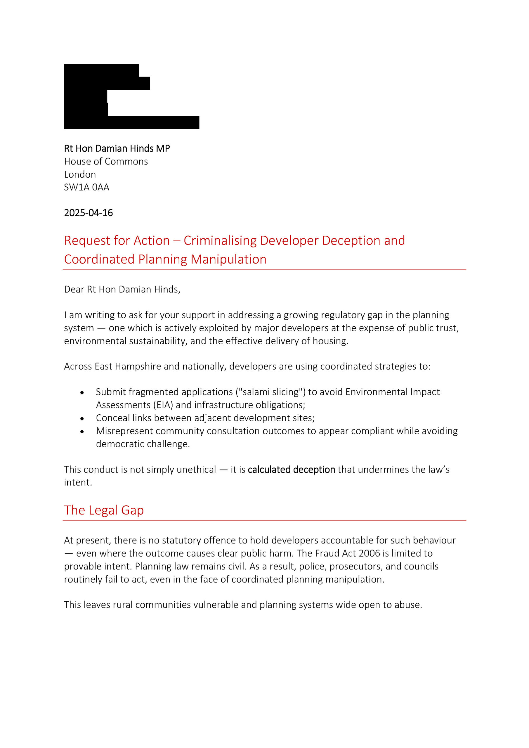
On 16 April 2025, I formally submitted a request for Parliamentary action to Rt Hon Damian Hinds MP, raising concerns over the growing exploitation of loopholes in the planning system by major developers.
My submission included:
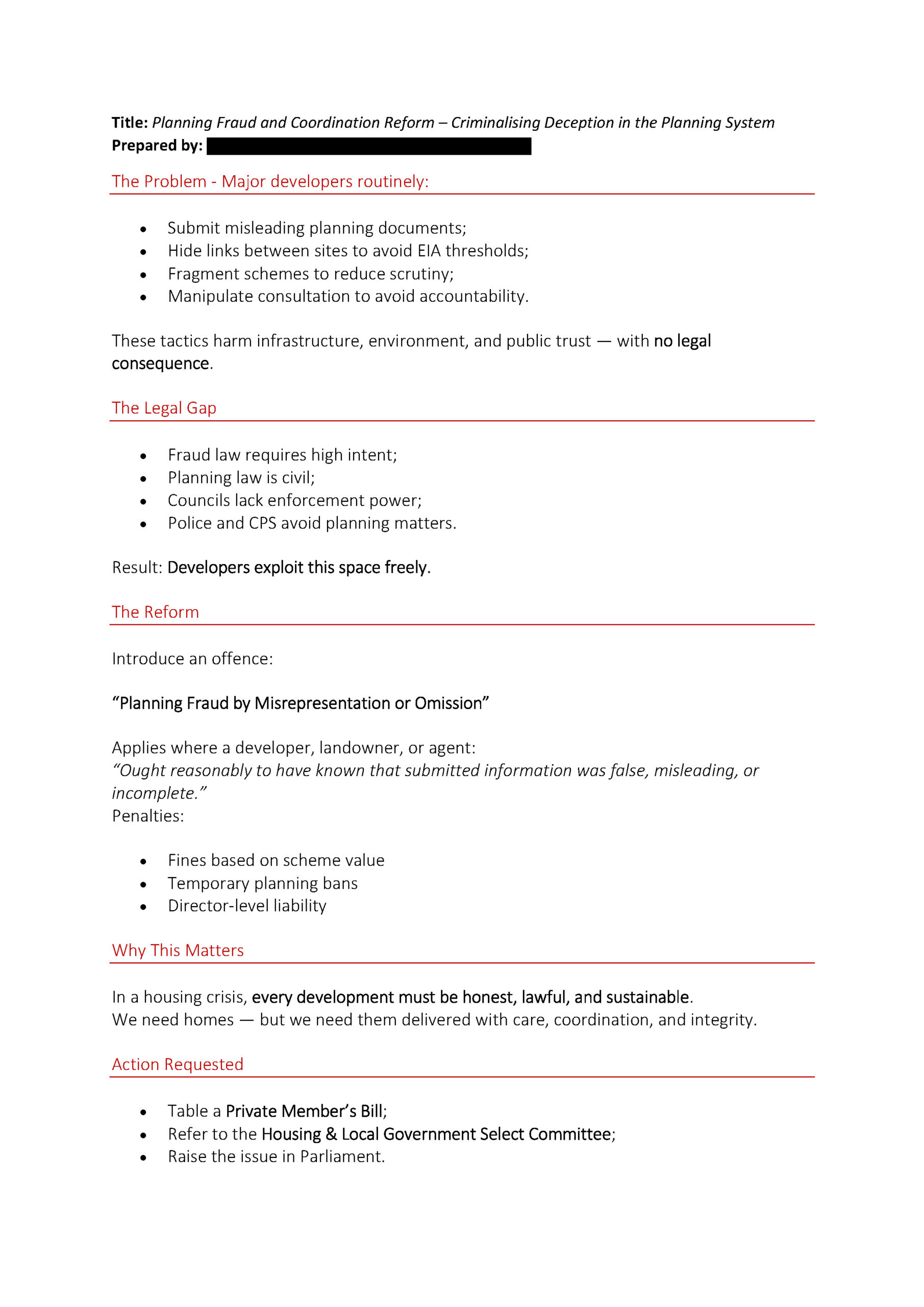
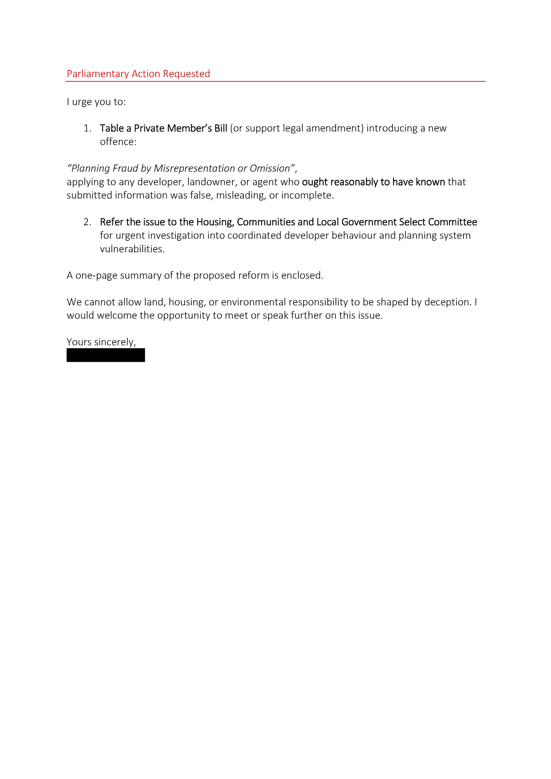
A letter requesting that Mr Hinds support the creation of a new criminal offence: “Planning Fraud by Misrepresentation or Omission”
A one-page proposal outlining the rationale and legal basis for this reform, including specific recommendations for Parliamentary and Select Committee action.
Damian Hinds’ office responded supportively and offered to forward the submission to the relevant Minister for a response on whether a legal gap exists.
I’ve confirmed that I welcome this step — but have also asked Mr Hinds to share his personal stance on the matter and consider using the other Parliamentary avenues at his disposal to support action. This issue goes beyond ministerial delegation: it is about public integrity, enforceability, and preventing systemic abuse in planning across the country.
This is the first step in what I hope will become a wider campaign to close the legal gap around developer deception and protect communities from coordinated planning manipulation.
More updates will follow as the response progresses.
The Proposal
I have asked Damian Hinds MP to:
Table a Private Member’s Bill, or support legal reform through other routes;
Refer the issue to the Housing and Local Government Select Committee;
Raise the matter in Parliament;
Use his position to support legislative engagement with DLUHC (Department for Levelling Up, Housing and Communities).
📉 What is Stock Market Manipulation?
Stock market manipulation refers to deliberately misleading the market to distort prices or trading volumes for personal gain. Common forms include:
Pump and dump schemes (artificially inflating share price then selling)
Spreading false or misleading information
Coordinated trading to create a false sense of demand
Wash trading (buying and selling to yourself to simulate activity)
⚖️ Is It Illegal in the UK?
Yes — under the Financial Services and Markets Act 2000 and Market Abuse Regulation (EU MAR), such conduct is strictly prohibited. The Financial Conduct Authority (FCA) can:
Impose fines
Ban individuals from working in financial services
Pursue criminal charges, which can carry up to 7 years’ imprisonment
🧩 So Why Is This Relevant?
Because in the planning system:
Developers can as of yet legally engage in landbanking, planning pressure tactics, and even site suppression for leverage — all of which are comparable in structure to stock manipulation — but face no criminal penalties.
In essence:
If you manipulate shares, you risk prison. If you manipulate planning policy, you might get a bonus.
Criminalising deception is a starting point — an absolute must — even if only as a preventative measure to make potential beneficiaries of such disinformation think twice before doing it again.
I’m just one person. A one-person orchestra trying to show the path forward — but I don’t expect things to change unless others stay vigilant too. One of the quiet goals of oligarchic systems — whether in authoritarian states or hidden within corporate lobbying — is to wear down public vigilance. To make the average person believe it’s too complicated, too fixed, or too late to challenge what’s wrong.
| Fair Scoring System for Housing Applications in a Land Supply Crisis |
📙 Disclaimer: This document is part of a conceptual set of proposals prepared independently by a resident of Medstead for illustrative purposes. It is intended to demonstrate the type of mechanisms and decision-making structures that may be needed to effect meaningful change and promote fair, transparent, and accountable planning in East Hampshire. While not representing adopted policy, the proposals are designed for practical use — and some mechanisms are suitable for immediate implementation, particularly given that EHDC is currently operating under the tilted balance, with real risk of cumulative harm to local communities. This contribution has been developed in good faith based on experience in business process architecture, informed by lived community experience, but produced without access to EHDC’s internal planning assumptions or systems. It was created by one person, in approximately two weeks, as a focused response to urgent and observable policy failures.
When a local council can’t show that enough land is available to meet housing targets — known as a Housing Land Supply Shortfall — national planning rules require a more flexible approach. This is called the tilted balance (as set out in Paragraph 11(d) of the National Planning Policy Framework1, or NPPF).
The purpose of the tilted balance is to ensure that councils continue to approve housing where it’s needed, even if their Local Plan2 is out of date — typically due to not being reviewed within five years, not aligning with national planning policy, or because the council cannot demonstrate a 5-year housing land supply3 — a target the council’s leadership must be willing to own and deliver on by taking responsibility as the accountable leadership team — so that housing delivery doesn’t stall.
It means that planning permission should usually be granted unless the negative impacts of a proposal clearly and significantly outweigh the benefits.
But that doesn’t mean any development should be approved, anywhere, at any scale. Without proper and fair policies in place, it becomes the wild west.
Don’t worry — the sheriff is in town: Points-Based Evaluation Framework for Tilted Balance Applications.
🧩 What is the Framework, and what are its Components?
The scoring framework is similar to the points-based immigration systems used in Canada or Australia — where multiple factors such as contribution, readiness, risk, and fairness are weighed to determine whether an application should succeed.
The Points-Based Evaluation Framework is the overall system or logic used to evaluate tilted balance applications. It ensures that each planning proposal is judged fairly, consistently, and transparently, especially when the Local Plan is out of date. It does so through structured criteria, clear scoring, and rules about proportionality and fairness.
🧰 Analogy
Think of the framework as the full toolbox.
The scoring matrix is the main tool.
The EIA thresholds and quotas are special attachments that make the tool adapt to the job. They are not side ideas — they are essential functional components of the framework.
Within this framework, there are two critical policy instruments that shape how the scoring matrix operates:
🔸1. Proportionate EIA Threshold Guidance – by Settlement Type
It helps trigger the Adverse Impact Multiplier in the scoring matrix.
It reflects scale sensitivity, so smaller villages aren’t hit by disproportionate risk.
It ensures fairness in how ecological and infrastructure capacity is judged.
Settlement Type
Population Range
Suggested EIA Trigger
Rationale
Small Village
< 1,000
30+ dwellings OR >10% population growth
High relative impact on infrastructure and character.
Large Village
1,000–4,999
50+ dwellings OR >7% population growth
Moderate impact; infrastructure may be strained.
Town
5,000–10,000
75+ dwellings OR >5% population growth
Risk of local congestion or infrastructure lag.
Large Town / Urban
10,000+
100+ dwellings OR >3% population growth
Only large proposals expected to trigger EIA.
This tiered structure helps ensure that growth is scrutinised proportionally, aligning with both national policy intent and local planning equity.
📘 Note on Growth Period Calculation: Growth percentages used to trigger Environmental Impact Assessments (EIAs) or influence scoring (e.g. under Cumulative Development Pressure) should be calculated using a rolling 10-year baseline. This aligns with Local Plan methodologies and national planning practice. EHDC may measure growth by comparing the population or dwelling figures from 10 years ago (e.g. using Census or mid-year estimates) to current or proposed development levels. This ensures growth assessments remain consistent, current, and proportionate across different settlement sizes.
🔸2. ⚖️ Fairness, Quotas
This introduces a quota-based logic for sharing the burden of new housing development fairly across the district — based on each settlement’s population.
✅ How it fits into the framework:
It informs the “Exceeded Local Tilted Balance Quota” category in the matrix.
It prevents overloading some areas while others under-deliver.
It ensures solidarity, proportionality, and public trust.
A key feature of this system is the implementation of quota-based modules, similar to fishing quotas, ensuring each settlement receives a fair share of tilted balance development annually. This approach prevents any single area from being disproportionately burdened by new, potentially riskier developments — especially during periods when delivery obligations are not being met elsewhere due to the use of the tilted balance route. It protects communities while the tilted balance workaround remains in use.
This approach reinforces solidarity and proportional political accountability — since population is linked to the number of councillors representing each area. If tilted balance developments concentrate in areas with fewer councillors, it undermines democratic fairness. This system ensures the burden of addressing housing shortfalls is shared fairly across EHDC by embedding the quota module into the tilted balance evaluation process.
📝Calculating Local Quotas
Example 1: Medstead
Example 2: Alton
Population: 3,016 District population: 125,700 Shortfall-based cap: 2,036 dwellings Calculation: (3,016 ÷ 125,700) × 2,036 ≈ 49 homes max in period 2024 – 2029
Population: 17,800 District population: 125,700 Shortfall-based cap: 2,036 dwellings Calculation: (17,800 ÷ 125,700) × 2,036 ≈ 288 homes max in period 2024 – 2029.
As of April 2024, East Hampshire District Council (EHDC) has reported a shortfall of 2,036 dwellings, representing only a 2.7-year housing land supply.
Shortfall: As of April 1, 2024, EHDC reported a shortfall of 2,036 dwellings in its five-year housing land supply, equating to a supply of only 2.7 years instead of the required five years.
Delivery Period: This shortfall pertains to the five-year period from April 1, 2024, to March 31, 2029.
In the absence of updated deliverability data, this full shortfall may be used as a provisional guide for calculating the annual tilted balance quota. This figure should be reviewed annually in line with updated housing monitoring reports.
Population figures used here are based on the 2021 Census, which recorded approximately 125,700 residents in East Hampshire District. These figures are factual and not modelled, and are therefore updated only once every ten years.
📊 Fair Distribution Method
To ensure a proportionate and community-led approach, each settlement’s share of the tilted balance quota can be calculated using the following formula:
Settlement share of the quota = (Settlement population ÷ District population) × District tilted balance allocation
This method ensures fairness based on the relative size of each settlement and promotes a more balanced distribution of housing delivery across the district.
Where detailed settlement-level data is unavailable or unclear, parish boundaries may be used as a practical proxy for administrative purposes.
🧮 Example Allocations
A village with 1,300 residents (approximately 1% of the district population) would be assigned a tilted balance quota of 5 homes per year.
A larger town with 10,000 residents (around 8% of the district population) would have an annual quota of approximately 38 homes.
📊 Sample Quota Table (based on a 500-unit district-wide annual tilted balance cap)
Settlement
Population
% of District
Annual Quota
Medstead
3,016
~2.32%
12 homes
Four Marks
4,000
~3.08%
15 homes
Alton
17,800
~13.7%
69 homes
Liphook
8,600
~6.62%
33 homes
Whitehill & Bordon
14,000
~10.77%
54 homes
Village A (1,000)
1,000
~0.77%
4 homes
🟠 Rationale and Scope
🟠 Rationale: This score reflects the principle that meaningful local input must be considered in planning decisions. It penalises developments where unresolved community objections highlight risks or overlooked impacts.
📘 Scope note: This score focuses on the collective substance and volume of material planning concerns from residents, parish councils, and statutory consultees. It does not double-count technical constraints already assessed under “Infrastructure Pressure” or “Biodiversity Net Gain.”
🧮 Scoring Matrix
The BETA version of a scoring matrix below provides a table that assigns numerical values (scores) to key planning criteria used to evaluate housing applications submitted under the tilted balance.
Each scoring range corresponds to specific planning factors and helps ensure that decisions are consistent, transparent, and defensible. This method supports officers, councillors, and developers in understanding how benefits and harms are balanced under the tilted balance policy.
Category
Scoring Range
Example Criteria
Undeveloped Allocated Land
–17 or 0
–17 if the applicant, or any entity with a material interest in the application (including parent companies, joint ventures, nominee partnerships, or directors/principal shareholders), also controls land that is allocated within the current or previous Local Plan and remains undeveloped without valid justification (e.g. unresolved access, contamination, legal constraint). Valid reasons must be disclosed at the time of application and logged by EHDC with a remediation plan and deadline. Lack of progress by the next Local Plan review may trigger review or deallocation of that land. This clause applies regardless of whether the undeveloped land and the tilted balance site are held under the same company name, partnership, or ownership vehicle, and includes associated companies or controlling interests. Additionally, if the applicant is promoting a windfall site under tilted balance while controlling undeveloped allocated land (without valid constraint), this penalty also applies in full. This is to prevent the circumvention of Local Plan delivery responsibilities through speculative use of unallocated land, which defeats the purpose of the tilted balance and results in adverse impacts that clearly outweigh the benefits by that reason. Score 0 if no such undeveloped allocated land exists, or if all constraints are documented and time-limited, or if full delivery progression is evidenced (e.g. planning submitted, access resolved, remediation underway).
🟠 Rationale: This combined rule discourages speculative land control, landbanking, and strategic sequencing of windfall sites ahead of allocated obligations. It ensures that developers demonstrate commitment to plan-led delivery before accessing the benefits of tilted balance and prevents gaming through nominee companies or secondary applications while core delivery is delayed.
📘 Scope note: This score applies to undeveloped land allocated in either the current or previous Local Plan and applies across ownership and control structures. It explicitly includes circumstances where a windfall site is used to bypass delivery expectations. It does not penalise small-scale or unrelated windfall applications, nor does it duplicate the “Delivery Speed and Certainty” score, which relates to the current proposal only.
Exceeded Local Tilted Balance Quota
–17 or 0
–17 if a settlement has already reached its annual tilted balance quota (based on population and EHDC’s district-wide shortfall, e.g. 2,036 units in 2024), or if a single planning application proposes more dwellings than the total annual quota for that settlement. EHDC may request resubmission in phases or apply conditions to align delivery with the annual quota. Score 0 if the quota has not yet been reached elsewhere.
Developers can exploit tilted balance due to this shortfall, even though some communities like Medstead have already over-delivered. That’s why your local quota calculation (e.g. 2.3% of 2,036 = ~47 units) is based just on the shortfall, not the long-term housing target.
Affordable Housing Contribution
–2 to +5
+5 for exceeding policy requirements by 30% or more.
Delivery Speed and Certainty
–1 to +4
+4 if full build-out achievable within 3 years with no major constraints.
Infrastructure Pressure
–3 to +2
–3 if severe GP/school congestion is identified and unmitigated. +2 if robust evidence of infrastructure alignment and mitigation is provided.
🟠 Rationale: This score rewards developments that actively support public service capacity and penalises proposals that would place additional strain on already-stressed infrastructure. It recognises that delivery without mitigation undermines community sustainability.
📘 Scope note: This criterion specifically evaluates the technical and service-level capacity of healthcare, education, and transport systems. General resident sentiment about overdevelopment should be reflected separately in the “Local Community Objection Level” score.
Biodiversity Net Gain / Land Use
–2 to +3
+3 for 20%+ biodiversity gain or brownfield remediation.
Developer Track Record
–2 to +2
+2 for consistently timely delivery on previous local schemes.
Local Community Objection Level
–3 to 0
–3 if the majority of consultees raise unresolved material concerns (e.g. transport, infrastructure, overdevelopment) that remain unaddressed in updated plans or mitigation responses. Score 0 if consultation feedback has been substantively addressed or is neutral/minor in planning terms.
🟠 Rationale: This score reflects the principle that meaningful local input must be considered in planning decisions. It penalises developments where unresolved community objections highlight risks or overlooked impacts.
📘 Scope note: This score focuses on the collective substance and volume of material planning concerns from residents, parish councils, and statutory consultees. It does not double-count technical constraints already assessed under “Infrastructure Pressure” or “Biodiversity Net Gain.”
Adverse Impact Multiplier
Multiplies total negative score by 1.5 only if: (1) the cumulative threshold for triggering an EIA was already met prior to this application, (2) no EIA or equivalent cumulative evidence was produced during previous developments, and (3) statutory consultees now face a data gap that prevents proper assessment.
Land Supply Contribution (5YHLS)
–2 to +4
+4 if the proposal contributes positively to the district’s 5-year supply (up to the quota limits for the tilted balance application). Score 0 if neutral. Score –2 if the development is proposed in a parish or ward that has already met or exceeded its Local Plan delivery targets (regardless of whether the plan is outdated), in order to protect communities that have already delivered their expected share.
Total possible score range: –34 to +25
⚖️ Decision Threshold Rule:
This rule ensures that the tilted balance is not misapplied to override critical delivery failures, settlement saturation, or harm that significantly undermines public trust, infrastructure, and local planning integrity.
No positive weighting or “exceptional justification” may override this threshold where the applicant controls undeveloped allocated land without valid constraints or where the local tilted balance quota has been exceeded.
✅ Total possible score range varies depending on multiplier status. Scores are designed to guide — not automate — decisions. However, any departure from the scoring framework must be supported by clear, proportionate reasoning. Failure to do so may expose the decision to legal challenge. This is precisely what makes the system strong: it provides EHDC with a structured, transparent and legally defensible tool for decision-making, while preserving councillor discretion — provided that discretion is accountable and properly justified.
Category Summaries:
Undeveloped Allocated Land: Considers whether the applicant is already holding undeveloped land within the district and whether valid constraints exist.
Exceeded Local Tilted Balance Quota: Evaluates whether the proposed number of homes exceeds the local quota for tilted balance development.
Delivery Speed and Certainty: Favors developments with a high probability of delivery within 3 years.
Infrastructure Pressure: Penalizes developments likely to stress healthcare, schools, or transport infrastructure without mitigation.
Biodiversity Net Gain / Land Use: Recognizes strong environmental gains or brownfield redevelopment.
Developer Track Record: Considers the applicant’s reliability in delivering on previous local developments.
Local Community Objection Level: Penalizes where material concerns remain unresolved by residents or community groups.
Statutory Consultee Objection Level: Reflects unresolved concerns raised by statutory consultees such as the Environment Agency or Natural England.
Land Supply Contribution (5YHLS): Rewards schemes that contribute positively to the district’s housing supply — but protects communities that have already delivered.
Adverse Impact Multiplier: Applies a 1.5x penalty if cumulative impact thresholds were previously exceeded but no cumulative EIA or mitigation evidence was gathered.
Component
Points-Based Evaluation Framework for Tilted Balance Applications
What It Delivers
A legally robust, transparent tool for evaluating tilted balance applications. Uses a scoring matrix, quota logic, and proportionate EIA thresholds to ensure consistency, fairness, and public accountability.
Function
Scores key planning criteria (e.g. land banking, delivery speed, infrastructure pressure, public objections). Applies quotas to prevent overburdening settlements and triggers multipliers where EIA safeguards were bypassed.
Legal Basis
Paragraph 11(d) of the National Planning Policy Framework (NPPF); Administrative discretion under planning law; Principles of fairness and proportionality; aligns with best practice case law.
Completion Criteria
Framework piloted in major out-of-plan applications submitted under the tilted balance. Matrix scores published with officer reports. Quota tables and EIA thresholds embedded in the assessment process.
How to Implement
Internally draft matrix, quota tables, and EIA thresholds. Pilot using current shortfall data. Publish template with explanatory guidance for officers and developers.
Timeline
Draft within 2–3 months. Run 6-month pilot phase. Evaluate and integrate into planning guidance.
Owner
Planning Policy / Development Management Officers / Legal Services. Coordination with Monitoring & Housing Delivery teams.
Footnotes
The National Planning Policy Framework — or NPPF — is the government’s main set of planning rules and principles. It guides how decisions should be made on housing, transport, design, environment, and sustainability across England. Local planning policies are expected to follow it.↩︎
A Local Plan is a council’s strategic planning document — it sets out where development should take place, what should be protected, and how local growth will be managed over the next 15–20 years. It must be reviewed at least every five years to remain valid.↩︎
What does it mean if a council "cannot demonstrate a 5-year housing land supply"? A council is required to show that it has enough deliverable housing sites to meet at least five years' worth of housing need, based on government-assessed targets.↩︎